It's a matter of scale. Even on a modern HSI, the difference in distance between the runway and the parallel taxiway is probably the width of the indicator icon. Very hard to see on instruments. Much easier to see by looking out the windscreen.
I can't tell if my expectations are just too high, but the impression I'm getting from all your answers is that pilots just don't have a dynamically updating (i.e. digital) map. It seems like everything is a bunch of numbers the poor pilots have to crunch or ticks that they have to count correctly or sheets of paper they have to pass to each other with diagrams. Why in the world is the system so ancient in 2017? Google Maps on my phone can show me where I am within 10 meters and where I'm going for the next 10 minutes, and it automatically zooms in and out at turning points... why can't an airplane have a display that shows them where they are and where they're going within the next minute?
Ironically, it is mainly because of reliability. Every system on an aircraft HAS to have double or triple redundancy by law, and a lot of these systems ARE antiquated by usual consumer standards.
A lot of pilots these days have iPads in the cockpit to assist with this, but in nearly all airlines and aircraft types, these are unauthorised devices that are not part of the certification. Generally they are used for non critical things like manuals or checklists, but I know of pilots that use them for situational awareness as well. In an accident though, this may work against them, badly.
Yes, it is the old legal and liability issue. Aircraft systems should be upgraded, but the cost of upgrading an entire fleet is prohibitive for most airlines that are already operating on the smell of an oily rag. New generation aircraft are getting better at it though. Like I mentioned before, I believe the 787 now has a HUD of sorts, which is long overdue.
You know what else Google maps does? It quits working at random times and behaves unpredictably in low precision GPS scenarios.
GPS units certified for aviation are tested to edge cases for usability with predictable and clearly indicated failure modes. This slows down new tech, but it's critical.
Even auto zooming on gmaps seems like a no-brainer, except for the times where the auto zoom into a trivial maneuver (continue onto road) occludes the difficult immediately following procedure (take correct exit out of 4 within 50 meters).
Okay, correction. Airplanes don't have GPS systems that work better at the level of reliability required. "It works most of the time, except it sometimes doesn't" might be sufficient when you can stop at the roadside, but doesn't quite cut it in the air.
Okay so let me get this straight: you're telling me that passenger airplanes currently fly by dead reckoning or stellar navigation or ground-based triangulation or something else? When a pilot doesn't know where he is, he doesn't have any kind of certified GPS-based system handy to tell him?
And moreover, even beyond GPS: how the hell can a plane's navigation system be capable of (and certified for!) landing the monster under autopilot, and yet not be able to tell the pilot its own location within the accuracy of a few feet reliably? I literally do not understand how what you're saying makes any sense.
Automatic landing systems rely on ground support by way of microwave signals from transmitters installed near autoland-capable runways. There's no general position information, and the airborne part of the system can't operate independently of the part on the ground.
Civilian GPS signals are limited in terms of position accuracy, too. I believe the CEP is ten meters. That's not bad, but it's not good enough to land an aircraft. Altitude information from GPS is (IIRC) either nonexistent or severely limited, too. About any aircraft with a glass cockpit is going to support a moving map display, and those do see use - but, as a couple of professional pilots in this thread have noted, during final approach the main concern with regard to aircraft position is relative to the glide slope and the runway, and a moving map has nothing to do with any of that.
On a more general note, it is remarkable to me that so many otherwise apparently sensible software engineers seem to regard aviation as a problem trivially susceptible of perfect solution - every time we here on HN discuss any sort of mishap even peripherally involving any aircraft, the same suggestions invariably arise around automation, various schemes of runway lighting, cockpit lighting, instrument augmentation or replacement, pilot augmentation or replacement...
One would tend to imagine that the history of our attempts to perfect our own craft - including those attempts which we who build and maintain software make anew every day - would give us cause for humility on the subject of fields other than our own, about which in the main we know next to nothing.
Imagine five hundred airline pilots confecting an ad-hoc, long-distance postmortem
of the recent us-east-1 incident! You'll have to imagine it, because it did not happen - and it is rare at best in my experience for pilots, because they are skilled in one highly complex and technical field, to imagine they can speak authoritatively in the context of another. Perhaps we might profit by their example.
> Automatic landing systems rely on ground support by way of microwave signals from transmitters installed near autoland-capable runways. There's no general position information, and the airborne part of the system can't operate independently of the
part on the ground.
Yes, I understand the landing portion has other kinds of support. However, I don't understand how it can not have the positioning information we need, because {see next response below}.
> Civilian GPS signals are limited in terms of position accuracy, too. I believe the CEP is ten meters. That's not bad, but it's not good enough to land an aircraft. Altitude information from GPS is (IIRC) either nonexistent or severely limited, too. About any aircraft with a glass cockpit is going to support a moving map display, and those do see use - but, as a couple of professional pilots in this thread have noted, during final approach the main concern with regard to aircraft position is relative to the glide slope and the runway, and a moving map has nothing to do with any of that.
This seems to contradict with what I read [1]. See this quote, for example:
Generally, the pilot will handle takeoff and then initiate the autopilot to take over for most of the flight. In some newer aircraft models, autopilot systems will even land the plane.
OK, so I don't have much of an expectation for older plane models, but my interpretation of the above is that in newer models, autopilot need not disengage before landing and require manual intervention in order to align the plane with the correct track (barring bad weather or other unusual situations like bird collisions, etc.). This is supported by the fact that they later explicitly mention that autopilot occasionally disengages. So it seems clear in normal situations autopilot has plenty of positioning available to it, enough to find the runway and locate the plane on a display of some sort. That goes pretty clearly against what you said. Am I missing something?
> On a more general note, it is remarkable to me that so many otherwise apparently sensible software engineers seem to regard aviation as a problem trivially susceptible of perfect solution
I hope this isn't referring to me, because I've been trying pretty hard not to give that impression (which I don't have). I never suggested anything about aviation perfection in general. I'm specifically talking about this particular kind of problem, because it seems to me that with current technology, pilot errors of this kind should be completely avoidable using current technology and, basically, non-problems in the first place. (Again: note that I said these types of pilot errors should be avoidable. I didn't say all faulty landings on the wrong tracks should be unavoidable.)
In other words, nowhere did I suggest that I think airplanes can fly or land themselves perfectly in unfavorable conditions. But this was quite a favorable condition for an automated system.
And, as a computer scientist, what seems ridiculous to me is the idea that "Oh, but this system you just described won't work if there is a hurricane and there are turkeys getting rammed through our engines while the pilots are asleep and ATC happens to be on strike in the middle of a nuclear holocaust, so let's "be conservative" and never approve it because it's clearly going to make things worse on average".
> OK, so I don't have much of an expectation for older plane models, but my interpretation of the above is that in newer models, autopilot need not disengage before landing and require manual intervention in order to align the plane with the correct track (barring bad weather or other unusual situations like bird collisions, etc.).
What is your definition of manual intervention? Pilots get updated instructions from the tower - the GPS path of the flight within 10 m is not programmed from the beginning due to weather issues, turbulence, traffic at the terminal ends, etc. The pilots hands may not be on the yoke, but they certainly are sending changes to the flight computer throughout the flight.
> So it seems clear in normal situations autopilot has plenty of positioning available to it, enough to find the runway and locate the plane on a display of some sort. That goes pretty clearly against what you said. Am I missing something?
Autopilot landings require a Cat III approach. There are currently no GPS (also known as GBAS for Ground Based Augmentation System) Cat III approaches approved in the US. The autopilot when landing is not using GPS for final approach. The pilot has pre-programmed in the waypoints labeled in the approach plate for the specific runway approach they've been told to take, and then they will switch over to the ILS approach.
The tone of many comments here (yours too) call out people who actually know how the system works and question them. The person you're trading comments with has said twice that GPS is not responsible for the autolanding portion of the flight. They even gave a summary of how instrument landing works - microwaves transmitted on specific frequencies in a specific pattern. You twice try to refute it. And then in your last paragraph you do exactly what he says the software engineers here do and you take offense to!
> sensible software engineers seem to regard aviation as a problem trivially susceptible of perfect solution
> And, as a computer scientist, what seems ridiculous to me is the idea that "Oh, but this system you just described won't work if there is a hurricane and there are turkeys getting rammed through our engines while the pilots are asleep and ATC happens to be on strike in the middle of a nuclear holocaust, so let's "be conservative" and never approve it because it's clearly going to make things worse on average".
Landing a big aircraft is not the easiest thing in the world, if only because the fate of hundreds of people rest in your hands. If you have a system that is designed to cut out the human component, it has to be all or nothing. As we learned from Asiana 214, when pilots have no actual practice doing something even in the absolute best of conditions and still cause loss of aircraft and life, how are they expected to perform when everything is going against them at the exact moment autolanding fails? Everything about flight training is preparing for the worst case, and practicing your skills over and over and over. Complacency can kill people when the margin of error between life and death is razor thin.
I was thinking of autopilot disengaging, but that's not really important here. I'll go along with what you just said.
> Pilots get updated instructions from the tower - the GPS path of the flight within 10 m is not programmed from the beginning
not in the beginning... so it is later?
> due to weather issues, turbulence, traffic at the terminal ends, etc.
Uhm, "traffic at terminal ends" suggests the real problem is that the correct path is not known in the beginning, or that autopilot might not be able to avoid collision on its own... which is quite a bit different from the plane being unable to locate itself accurately and follow the correct path even if it were known a priori. Are we even discussing the original issue at this point?
> Autopilot landings require a Cat III approach.
I have no idea what that means. I'm not sure what gave you the impression that I know what that means either.
> The autopilot when landing is not using GPS for final approach.
> The person you're trading comments with has said twice that GPS is not responsible for the autolanding portion of the flight.
> You twice try to refute it. And then in your last paragraph you do exactly what he says the software engineers here do and you take offense to!
I think you didn't read my last comment carefully because, as I already said, I understood this. My problem is whether GPS is accurate/reliable enough to lead the plane to the place where the next system can take over, which to me implies GPS is already certified to be accurate and reliable enough to get the plane near the correct runway. Read it again. There shouldn't be a single sentence there where I "refute" the microwave transmissions or claim GPS is actually used on the final approach.
> If you have a system that is designed to cut out the human component, it has to be all or nothing.
Wha..? Autopilot isn't perfect either, and can disengage in various situations that it can't handle, but they approve it and pilots manage to use it just fine. When it's GPS's turn, suddenly it has to be 100% perfect?
And when did I ever suggest you have to cut out the human component? For goodness's sake all I'm asking for is a little display with a map that shows where the plane thinks it's going. That's "cutting out the human component" to you?
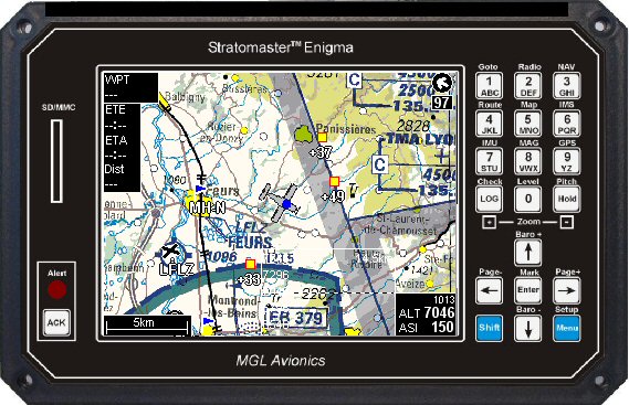
No, they don't already do this. As 'phdp already explained, there are no instrument landing systems installed in the US which include GPS augmentation. So, while the moving map will show the same position information as at any other time when the aircraft's GPS receiver has sufficient signal, it's going to look something like this: http://www.stratomaster.eu/lignes/mgl/photos/enscr4.jpg
As far as "stupid mistake" goes, you sure do seem quick to judge professionals in a highly technical field totally unrelated to your own, and of which you've made clear you are happy to preserve your ignorance. Were I you, I'd hope my own errors meet with a greater extent of charity than that precious little you see fit to mete out. But that's your problem, not mine. Good luck with it.
> As far as "stupid mistake" goes, you sure do seem quick to judge professionals in a highly technical field totally unrelated to your own
The heck? Everyone makes stupid mistakes. Hell, I make more of them than a lot of people I know. That's why there are procedures and checklists and redundancies and automated systems -- to prevent stupid mistakes, evne by the best people. Where was I ever judging the pilot for heaven's sake?! Maybe you could be a little more charitable with how you judge people?
I mean you've already said you don't know what you're talking about ("I have no idea what [Cat III] means.") but you're totally cool with taking a confidently authoritative tone on it anyway, I'm not sure what other conclusion anyone should be expected to draw.
> I mean you've already said you don't know what you're talking about ("I have no idea what [Cat III] means.") but you're totally cool with taking a confidently authoritative tone on it anyway, I'm not sure what other conclusion anyone should be expected to draw.
...Did you come here just to fuel flames and burn people, or are you here to have a legitimate discussion about the subject?
You're totally cool being literally in ad-hominem territory at this point and you're lecturing me about not judging people I never even judged?
Is it really ad hominem to draw uncomplimentary conclusions from your evident disinterest in addressing substantive criticisms of the argument you're advancing? I don't think it is. Perhaps I'm wrong about that - but what else are you giving me to work with?
> Uhm, "traffic at terminal ends" suggests the real problem is that the correct path is not known in the beginning, or that autopilot might not be able to avoid collision on its own... which is quite a bit different from the plane being unable to locate itself accurately and follow the correct path even if it were known a priori. Are we even discussing the original issue at this point?
Your thesis of your statements is that it is ridiculous that there is no moving map for pilots to see on the airplane. You've been told directly by some commenters that there is (tuxer), and others, including me, have said that GPS is not the way to land a plane.
>I have no idea what that means. I'm not sure what gave you the impression that I know what that means either.
I mean this in a positive way, but you should look it up on wikipedia. There are many great articles about the systems in place for instrument approaches and landings, and you may learn something interesting for a quick 15 minute investment.
> My problem is whether GPS is accurate/reliable enough to lead the plane to the place where the next system can take over, which to me implies GPS is already certified to be accurate and reliable enough to get the plane near the correct runway. Read it again.
You call us out for dismissing your idea (And, as a computer scientist, what seems ridiculous to me is the idea that "Oh, but this system you just described won't work..."), which to mean seems to be some sort of GPS en-route to to landing automated system. This idea has been informed by your inaccurate reading of a CNBC article (So it seems clear in normal situations autopilot has plenty of positioning available to it, enough to find the runway and locate the plane on a display of some sort. That goes pretty clearly against what you said. Am I missing something?). The en-route exists but can often change from the time the plane leaves the ground to when it gets within 50-100 miles of the airport, at which time it might be disengaged and switched to VOR based navigation. The landing by GPS does not exist because it is a lot less accurate than the existing systems.
This branch of the thread is about auto landing, and you were talking about how it's absurd GPS is approved for automated flying. Given that GPS is used for en-route navigation and not landing, the assumption was that you were proposing GPS landing systems. That is what my comment is about. And yes, having autopilot disengage at 50 feet above the ground when the pilot is not expecting it can be fatal. I would say that for the landing stage it has to be all or nothing. And you've been suggesting cutting out the human component by proposing an system that goes from take off to landing without manual intervention! Even if there is still a pilot in the cockpit, it still takes a few seconds for the brain to spin up to take over a task from the computer.
It's awesome that as someone outside the aviation industry, you're curious about how it works. Your incredulous tone and sense of superiority (As a computer scientist, as if we should automatically and uncritically defer to your opinion, and I say that as a programmer) is a bit off-putting. If you had just done the basic amount of research you could have come back with a list of questions such as:
- Is GPS used to navigate planes from take off to landing? What else is used?
- Why was the pilot in this incident not using automation to land the plane? How often does this happen?
- What is the procedure for switching between different navigation technologies at different points of the flight? I know that take offs and landings can be manual, but when does autopilot kick in?
- Why is GPS not used to land planes?
- What equipment to pilots use in the cockpit? If they are not the latest and greatest, why?
We could then have had a proper discussion surrounding the need for backwards compatibility, the rolling out of ADS technology, how its absurd we still use voice over radio as a primary way of relaying commands, etc. Pilots and others in the aviation industry generally do believe that a lot of the technology guiding our largest planes is antiquated, but you trivialize it without understanding the full context.
>The tone of many comments here (yours too) call out people who actually know how the system works and question them.
Lack of enough common frame of reference that the ability to communicate is almost totally inhibited from the word go. It reminds me of the Feynman magnets youtube video. The interviewer asks Feynman to explain the attraction repulsion sensation and Feynman admits any correct answer the interviewer will not understand because he doesn't understand any of the basic prerequisites of having a conversation; and any answer he gives the interviewer would understand is cheating him out of the correct answer.
Seriously? From here, it looks as if you're doing your best in refusing to understand. Here's a hint: context. If you're en route, even an approximate position within hundreds of feet is great for navigation; please stow your straw men back where you found them.
In this case, the issue is with landing, where you need a precise position; "probably tens of feet, when it works" is exactly the sort of accuracy that's not good enough. As for "know where it is and land" - that's already there, is called Precision ILS, and uses no elements of GPS whatsoever.
The issue is you're treating this as though (1) cruising can be done on autopilot via GPS because it doesn't need much accuracy, (2) landing can also be done on autopilot because we have more accurate systems, but (3) the transition between the two requires manual intervention because the plane can't reliably locate itself accurately enough to get in the right position for landing systems to take over.
But that simply doesn't seem to be the case (in normal weather, which we had here). See my reply to a sibling comment here for a link. It seems that in normal conditions planes are capable of doing it all in one go, which means they are capable of accurately and reliably locating themselves. Nobody is expecting these to work in extreme conditions like bad weather or bird collisions, but in those conditions autopilot can and does already get disengaged (whether automatically or manually), and this could be done the same way. It's not like we forbid autopilot entirely because it isn't 100% perfect, so why not apply the same standards here?
Nope. (3) The transition between the two requires manual intervention, as those are very different flight modes, using different systems and there's no automagic way to switch between them; the quote from the linked article is an oversimplification akin to "computers can do almost anything - therefore what do we need programmers anyway?"
Oh, and aircraft DO have moving maps etc. now, but these are usually dialled out to show a range of hundreds of miles in cruise, and are not usually adjusted to show distances in mere metres when on final approach.
Once again, because these displays are usually on the centre floor console or located below the HSI, they are outside the 'scan zone' of a pilot on short finals.
In their defense, I would guess that making such a system 100% reliable and unintrusive may be a lot harder than we realize. It's not uncommon for Google Maps to be off by a few blocks for 10 seconds or more, and that could very easily be fatal if you're using it to land an airplane.
Are you suggesting their current GPS systems have that kind of issue though? I'm just asking for an interface to be added, not a entire concept of GPS functionality to be added. I'm assuming the latter is already used. It's not like I was suggesting they use Google Maps.